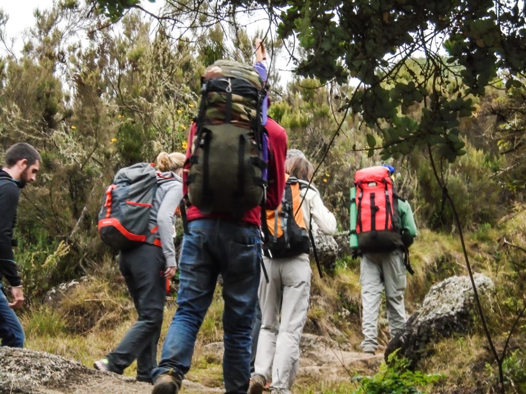
It is one thing to think about conquering the heights and a whole other dimension to actually get ready for a mountain climbing trip. Don’t be caught off guard, on top of world’s summits, realizing you’ve just forgot a handkerchief… Like seriously! Here’s a list of important things to bring on your next climbing trip.
For the head and face
Pile or Wool hat:
Bring one that covers ears — a balaclava type is excellent.
Shade Hat: Visor
hats with good brims are essential for protection from the equatorial sun.
Sunglasses: Essential
for eye protection in the tropics and at altitude. Bring a good quality pair,
preferably with an IREX protection rating of 100. Attachable side shields are
necessary, or bring glacier glasses.
Sunscreen: Bring
plenty of complete sun block with a sun protection factor (SPF) of 15 or more.
Unless you have spent time in equatorial sun you will probably underestimate
the amount necessary, so bring lots. Sunscreen is difficult to find in
Tanzania.
Lip Balm: With
SPF rating of 15 or higher.
Bandanas: Tied around the neck, they give good sun protection. Can also be used for cleaning glasses, as wash cloths, etc. They dry very quickly.
For the upper body
T- Shirts: Two T-
shirts that you don¹t mind getting dirty while on the mountain. Synthetic is
best — no cotton on summit day.
Upper Body Layers:
For climbing the mountain we recommend you have three warm layers for the upper
body. Items must be made of wool, synthetic or pile. Make sure all layers fit
comfortably over each other and supply good insulation. A good combination is a
long underwear top, a sweater, and a pile jacket or heavy wool shirt. Cotton
items do not provide adequate insulation and are completely
useless when damp.
Rain Parka: Afternoon
showers are common in East Africa, especially on the mountain. Bring a good
parka of Gore- Tex or waterproof nylon that has been “seam sealed”.
Wind Shirt: (optional
if you have Gore- Tex rain gear) A nylon wind shell (not waterproof), roomy
enough to fit comfortably over all upper body layers. Gore- Tex is good for
both this wind shirt and for the rain coat.
Poncho: (Optional)
Quick and handy protection for body and rucksack. Poor protection in windy
rain.
Gloves or Mittens: Wool
or pile. One pair of heavy mittens and a light pair of gloves work well.
Mitten Shells:
One pair to go over your mittens. These are for use against the winds sometimes
encountered in the crater and on the way to the summit.
For the legs
Quick Dry Hiking
Shorts: 1 pair. Good for hiking at lower elevations on the mountain.
Long Underwear
Bottoms: One pair. Wool or synthetic.
Wool, Bunting or Pile
Pants: One pair that fit loosely and is comfortable. These are essential to
be worn over the long john bottoms.
Rain Pants: Bring
a good pair of rain pants of Gore- Tex or waterproof nylon that has been “seam
sealed”.
Wind Pants: (optional
if you have Gore- Tex rain pants.) One pair. These are used often on the
mountain for protection against wind. They should be breathable nylon and roomy
enough to fit comfortably over wool or pile pants.
Tights: Lycra
types are best. These are comfortable to hike in, help prevent nettle stings,
provide good warmth on cool misty days, dry fast and prevent sunburn.
Undergarments: Enough
for the duration of the trek.
For the feet
Thin Socks: Two
pair of synthetic socks to wear under heavy wool socks. These help prevent
blisters and keep feet dry.
Thick Socks: Six
pair of heavy wool or synthetic socks to wear for warmth with hiking boots.
Hiking Boots: One
pair medium weight hiking boots large enough to be comfortable with one liner
sock and one heavy wool or synthetic sock.
Gaiters: One pair
of either high or low gaiters made of breathable material to keep dirt and snow
out of your boots.
Tevas, Sandles:
These are to wear in camp after a day of hiking.
For sleeping
Sleeping Bag and
Stuff Sac: On the mountain temperatures can get down to zero degrees
Fahrenheit at night so bring a warm bag.
Sleeping pad: A
closed cell foam camping mattress is OK. An inflatable Thermal Rest type is
more comfortable.
FOR DRINKING:
Water Bottle: Two,
one liter wide- mouthed plastic bottles.
Water Treatment:
This is very important. The water in East Africa is not unhealthy although its
flora content is different from what you are used to. To keep your system
running normally we recommend you bring two bottles of “Potable Aqua” or “Polar
Pure”, crystal iodine in a bottle, to treat drinking water. Filtration pumps
are also effective, but costly and rather bulky.
Water Flavoring:
Wyle’s lemonade, Tang, Gatorade, etc. These mixes are hard to come by in
Tanzania and make treated water taste much better. Double bag these.
For carrying your gear
Frameless Pack: A
medium size comfortable pack is adequate to carry personal gear. The pack
should fit properly and have a good waist belt. Side pockets are recommended
for soft packs. Personal loads with camera gear, water for the day and warm
clothes are often between 18 and 25 pounds.
Pack Cover: Something
waterproof to cover your pack when hiking in the rain. Otherwise bring a large
plastic bag to line the inside.
Duffle Bag:
Medium size with lock for mountain gear. This will go into our mountain bag
that the porters will carry.
Duffle Bag: Large
enough to hold your non- mountain gear. This will meet you at the hotel after
the climb.
Plastic Bags:
Several, to double bag your sleeping bag and clothes on the mountain. It can
rain every afternoon.
For Personal health and comfort
Toiletries: Bring
enough for entire trip. Keep simple and light. Few toiletries are available in
Tanzania, however, so bring enough for all your needs.
Ear Plugs: To
block out snoring and hut noise, to insure peaceful rest.
Flashlight and/or
Headlamp: Important on summit day and just plain handy in camp. Plenty of
batteries.
Pocket Knife: Simple
Swiss Army type with scissors.
Personal First Aid
and drug Kit: Please see recommended list below.
Trail Munchies:
Although plenty of snack food is provided, trekkers like that taste of home in
their pack. Touted as an important accessory by those who have brought them in
the past!
Hot Drink Mixes:
We will provide plenty of coffee, cocoa and tea, but non- caffeinated drinks
are not readily available here. Bring a supply of your favorite herbal teas.
Towel: For
washing up in camp, a small one is fine, or you can use a bandana.
Towelettes: Such
as “Wash’n’Dries” for general hygiene.
Spare Glasses:
For contact wearers in dusty conditions and any eyeglass wearer while on vacation.
Umbrella: Very useful against rain and sun. Most guides use one
There are two distinct trekking seasons which constitute the best time to climb Kilimanjaro. They are January-March and June-October.
Best Trekking Months for Kilimanjaro
January-March is generally colder than June-October and there is a higher probability of encountering snow on the summit. For some this might be seen as a negative, but the benefits of a January-March trek is that the slopes are often quieter at this time of the year.
The June-October trekking season coincides with the summer holidays in Europe and N.America and hence certain routes are often quite busy.
March, April and November are the wettest months on Kilimanjaro, and not ideal of trekking.
The Rongai route ascends Kilimanjaro from the northeastern side of the mountain and is normally accessed from Kenyan through the Loitokitok boarder crossing into Tanzania. It offers a unique and quality traverse of Kilimanjaro, approaching the peak by a remote track on the Kenyan side of the massif and reaching the summit (5896m) via the high altitude desert of the “Saddle” then descending on the Tanzania side through the Mweka trail. This route retains a sense of unspoiled wilderness and offers a totally different perspective of Kilimanjaro. Rongai Route is also apparently the easiest Mount Kilimanjaro trekking option with fairly gentle gradients and shorter daily trekking phases.
Kilimanjaro trek via Rongai Route (7 Days / 6 nights)
DAY 1: Nairobi – Oloitokitok BORDER We journey south through Kenya to Kibo Slopes cottages, a base camp near the border with Tanzania. The drive takes 4 hours, on the way we invariably spot zebra, giraffe and gazelle out on the plains.
Day 2: Rongai Gate (1950m) – 1st Caves camp (2600m) Hiking time: 5h Distance: Approximately 8 kms Habitat: Montane Forest Ascent: +650m After morning clearance with the Kenyan customs, we transfer to the Rongai trail head (1950m) in Nale Moru village of Tanzania, where our mountain crew will be waiting. We commence our climb on a small winding path that crosses maize fields before entering pine forest, and then climbs gently through a virgin, natural rain forest where colobus monkeys are common, before emerging to the lower moorland zone. Overnight camp at 1st Caves (2600m). Water can be found just down the trail below First Cave.
Day 3: 1st Cave (2600m) – Kikelewa Cave (3600m) Hiking time: 6 – 7h Distance: Approximately 10 kms Habitat: Moorlands Ascent: +1000m. The trail continues up towards Kibo, passing Second Cave (3450m) en-route, and reaching Kikelwa Cave at about 3600 metres. The views start to open up and you begin to feel you’re on a really big mountain! Water is in the obvious stream below the cave, although you need to wander downhill to fetch some. Overnight at 3rd Cave camp (Kikelewa Caves).
Day 4: Kikelewa Cave (3600) – Mawenzi Tarn camp (4330m) Hiking time: 3 – 4h Distance: Approximately 8 kms Habitat: Moorlands Ascent: +730m. A short but steep climb up grassy slopes offers superb views of this wilderness area. The vegetation zone ends shortly before you reach your next camp at Mawenzi Tarn spectacularly situated beneath the towering spires of Mawenzi. Spend the afternoon acclimatizing and exploring the area.
Day 5: Mawenzi Tarn camp (4330m) – Kibo hut (4700m) Hiking time: 4 – 5h Distance: Approximately 8 kms Habitat: Alpine desert Ascent: +370m. Continue ascending on the east side of Kibo crossing the saddle between Mawenzi and Kibo taking 4 to 5 hours to reach Kibo Hut. The remainder of the day is spent resting in preparation for the final ascent, which begins around midnight. Overnight at Kibo Camp.
Day 6: (Summit Attempt) Kibo hut (4700m) – Uhuru Peak (5895m) – Horombo hut (3720m) Hiking time: 8h to Uhuru, 6h to Horombo Habitat: Stone scree / ice-cap summit Distance: Approximately 6 kms ascent, 21 kms descent Ascent: 1195m. Descent: 2175m We are rise around 2330, and after some tea and biscuits you shuffle off into the night. This is where the going really gets tough. The first section of the trail consists of a rocky path to the Hans Meyer Cave (5150m), also a good resting spot. The path then zigzags up to Gillman’s point (5 681m), which is located on the crater rim. This section is very steep with a lot of stone scree, requiring a great physical and mental effort. Probably the most demanding section of the entire route. Do the Kili shuffle and move slowly.
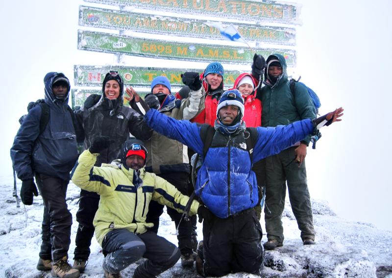
At the summit of Africa’s tallest mountain with a previous expedition
From Gillman’s Point you will normally encounter snow all the way up to Uhuru peak (5895m), the highest point in Africa. Total exhilaration and satisfaction – you made it. Weather conditions on the summit will determine how long you can spend, taking photographs, before the 3-hour descent back to Kibo hut. After a short rest you gather all your gear for the ascent and head down to Horombo hut (3 hours) where you will overnight. The return to Horombo hut will seem surprisingly fast compared to the ascent. The total time spent walking on this day is around 14 hours, so be prepared for a very tough day. Later in the evening you enjoy your last dinner (with soft drinks and beer for sale at the camp office) on the mountain and well-earned sleep, filled with memories and stirring emotions.
Day 7: Horombo hut (at 3720m) to Marangu Gate (at 1980m) Hiking time: 6h Distance: Approximately 27 kms Descent: -1740m After breakfast you continue your descent (6 hours), passing the Mandara hut, down to the Marangu gate. It is strongly recommended not to pay your porters any tips until you and all your gear have reached the gate safely. At Marangu gate you sign your name and details in a register. This is also where successful climbers receive their summit certificates. Those climbers who reached Gillman’s Point (5685m) are issued with green certificates and those who reached Uhuru Peak (5895m) receive gold certificates. You now drive to Arusha for a long overdue hot shower, dinner and celebrations!! Overnight in Impala hotel or similar.
Day 8: Arusha – Nairobi by road.(250kms) After breakfast we commence our journey back into Nairobi via Namanga and arrive in the afternoon hours.
Lemosho Route – (7 Days / 6 Nights)
The seven day Lemosho variation is preferred over the six day option because it breaks up day two into two days, providing better acclimatization and a more gradual ascent. On the seven day route, we walk from Forest Camp to Shira Camp 1 on day two, a reasonable altitude gain of 2,000 feet. Then on day three, we continue from Shira Camp 2 to the little used Moir Hut, at 13,800 feet. Overall the exposure to this altitude will help prepare the body for higher altitudes coming on the following days.
However, the trek from Barranco to Barafu, followed by the summit day are unchanged from the six day Lemosho variation. This schedule is still very tough, though the extra day on the mountain on the seven day route will help climbers deal with the exhausting itinerary better than those who opted for the six day route.
DAY 1: Londorossi Gate to Forest Camp Elevation (ft): 7,800ft to 9,500ft Distance: 6 km Hiking Time:3-4 hours Habitat: Rain Forest
We depart Moshi for Londorossi Gate, which takes about 4 hours, where you will complete entry formalities. Then drive to the Lemosho trailhead (another hour to reach the trailhead). Upon arrival at trailhead, we eat lunch, then commence through undisturbed forest which winds to the first camp site.
DAY 2: Forest Camp to Shira Camp 1 Elevation (ft): 9,500ft to 11,500ft Distance: 8 km Hiking Time 5-6 hours Habitat: Moorland
We continue on the trail leading out of the forest and into a savannah of tall grasses, heather, and volcanic rock draped with lichen beards. As we ascend through the lush rolling hills and cross several streams, we reach the Shira Ridge before dropping gently down to Shira 1 camp. The view of Kibo from across the plateau is amazing.
DAY 3: Shira Camp 1 to Shira 2 to Moir Hut Elevation (ft): 11,500ft to 13,800 ft Distance: 14 km Hiking Time: 5-7 hours Habitat: Moorland
We explore the Shira plateau for a full day. It is a gentle walk east toward Kibos glaciered peak, across the plateau which leads to Shira 2 camp on moorland meadows by a stream. Then we continue to Moir Hut, a little used site on the base of Lent Hills. A variety of walks are available on Lent Hills making this an excellent acclimatization opportunity. Shira is one of the highest plateaus on earth.
DAY 4: Moir Hut to Lava Tower to Barranco Camp Elevation (ft): 13,800ft to 13,000ft Distance: 7 km Hiking Time: 4-6 hours Habitat: Semi Desert
From the Shira Plateau, we continue to the east up a ridge, passing the junction towards the peak of Kibo. As we continue, our direction changes to the South East towards the Lava Tower, called the “Shark’s Tooth.” Shortly after the tower, we come to the second junction which brings us up to the Arrow Glacier at an altitude of 16,000ft. We now continue down to the Barranco Hut at an altitude of 13,000ft. Here we rest, enjoy dinner, and overnight. Although you end the day at the same elevation as when you started, this day is very important for acclimatization and will help your body prepare for summit day.
DAY 5: Barranco Camp to Karanga Camp to Barafu Camp Elevation (ft): 13,000ft to 15,000ft Distance: 9km Hiking Time: 8-10 hours Habitat: Alpine Desert
After breakfast, we leave Barranco and continue on a steep ridge passing the Barranco Wall, to the Karanga Valley campsite. Then, we leave Karanga and hit the junction which connects with the Mweka Trail. We continue up to the Barafu Hut. At this point, you have completed the South Circuit, which offers views of the summit from many different angles. Here we make camp, rest, enjoy dinner, and prepare for the summit day. The two peaks of Mawenzi and Kibo are to be seen from this position.
DAY 6: Barafu Camp to Summit to Mweka Hut Elevation (ft): 15,300ft to 19,345ft (and down to 10,000ft) Distance: 5 km ascent / 12 km descent Hiking Time: 7-8 hours ascent / 4-6 hours descent Habitat: Arctic
Very early in the morning (midnight to 2am), we continue our way to the summit between the Rebmann and Ratzel glaciers. You head in a northwesterly direction and ascend through heavy scree towards Stella Point on the crater rim. This is the most mentally and physically challenging portion of the trek.
At Stella Point (18,600 ft), you will stop for a short rest and will be rewarded with the most magnificent sunrise you are ever likely to see (weather permitting). From Stella Point, you may encounter snow all they way on your 1-hour ascent to the summit. At Uhuru Peak, you have reached the highest point on Mount Kilimanjaro and the continent of Africa. Faster hikers will see the sunrise from the summit.
From the summit, we now make our descent continuing straight down to the Mweka Hut camp site, stopping at Barafu for lunch. You will want gaiters and trekking poles for the loose gravel going down. Mweka Camp is situated in the upper forest and mist or rain can be expected in the late afternoon. Later in the evening, we enjoy our last dinner on the mountain and a well-earned sleep.
DAY 7: Mweka Camp to Moshi Elevation (ft): 10,000ft to 5,400ft Distance: 10 km Hiking Time: 3-4 hours Habitat: Rain Forest
After breakfast, we continue the descent down to the Mweka Park Gate to receive your summit certificates. At lower elevations, it can be wet and muddy. Gaiters and trekking poles will help. Shorts and t-shirts will probably be plenty to wear (keep rain gear and warmer clothing handy).
From the gate, you continue another hour to Mweka Village. A vehicle will meet you at Mweka village to drive you back to hotel in Moshi
Machame Route – (6 days / 5 nights)
Day 1: Nairobi-Moshi Leave Nairobi at 8:00am via shuttle to Moshi,arrive Moshi after 6/7hrs drive,check in to your hotel where you will have dinner and overnight after diner.After dinner you will get briefing about the next day programme
Day 2: Moshi Machame Camp After breakfast, the vehicle will transfer you to the start of Machame route’you will spend the day walking through a lush rainforest on Kilimanjaro’s lower slopes. This is generally a moderate day although poor weather can make it more demanding. Your first night camp on Kilimanjaro is about 3,000m above sea level(this is Machame camp) Hike time : 7hrs, Hike distance 10kms
Day 3: Machame camp-Shira Camp After an early morning breakfast,you hed across a stream valley before a 3/4hrs climb up a steep ridge.You then descend into a river gorge before climbing a more gentle slope to the moorland on the Shira plateau,a fascinating area of Kilimanjaro. Your night will be spent at Shira camp. Camp altitude: 3,850m Max.altitude :3,900m Hike time: 7hrs Hike distance: 8kms
Day 4: SHira camp-Baranco Camp. During this day,you have to walk 6-7hrs where you have the chance to enjoytypical Kilimanjaro vegetation such as senecio,Lobelia and Hilichrysum as well as Larva tower and distinct glaciers if weather is clear.Although you are at 4600m you then descend to camp at a lower level(excellent for your acclimatization and to increase your chances of success.At the path, you should be able to see Kilimanjaro Kibo peak.overnight to be spent at Barranco valley 3,950m.
Day 5 Baranco Camp-Barafu Camp Your route climbs the Barranco wall before leading a scree and ridge into Karanga valley,at this stage you are at 4,100m where you will have hot lunch,as you enjoy specutacular views of Kilimanjaro Westerb Breach,after lunch,you will climb slowly up a Morain ridge taking the views of the southern glacier and glacial valleys threading way down the Mountain.The final section to Barafu camp 4,600m is climbed slowly as it’s quite steep.
Arriving at the camp around 4:00pm,give you time to relax and prepare for the summit day to follow.After early dinner,you will have final briefing then top sleep.
Camp altitude 4,600m
Hike time:6hrs
Hike distance 8kms
Day 6: Barafu Camp-Uhuru Peak
You are set out towad summits of Kilimanjaro in the early hours of the morning, with guides alongside with you. This final ascent across the scree is taken very slowly but aim in steady progression towards the top,you pass between the Ratzel and Rebman glaciers before arriving at Stella point and Kilimanjaro Uhuru peak 5,895m.If you made a good time despite the reduction of oxygen this far above sea level,you may be in time to watch sunrise before you start your descends
A long day follows as your descend camp is pitched at Mweka at 3,100m
.
Camp altitude : 3,100m
Max. Altitude ; 5,895m
Hike time: 16hrs
Hike distance 14kms
Day 7: Mweka camp – Moshi Town Your final descent is through the mountain lower heath section and rainforest,you find yourself to the National park gate,you will then be tranfered to Moshi town after signing out and acquiring a certificate of achievement,where you will have hot-shower after which you will decide the nature of your own Kilimanjaro celebration-splash in pool,long hot-shower or drinks .Dinner and overnight in the hotel.
Max. Altitude :3,100m Hike time: 4hrs Hike distance 9kms DY 8 After pre-dawn breakfast in the hotel,you will be driven to the bus station /Airport depending on your mode of transport back to your destiny .
Umbwe Route (6 DAYS/5 NIGHTS)
DAY 1 Umbwe gate (1614m) to Umbwe cave camp (2850m), Hiking time: 6 Hours Distance:Approximately 10.3km Habitat: Forest (montane) After brteakfast you will be driven to the Machame gate where registration formalities will be completed. From the Machame gate you will be transferred to the Umbwe Gate(1641m),passing through villages with coffee and banana plantations.The air is thick with moisture and the path is usually muddy. The route intially follows a forestry track winding up through the natural rain forest.It then narrows and steepens to climb the ridge between the Lonzo and Umbwe rivers,with huge trees surrounding you.The path offers some spectacular views of deep gorges and if you are lucky,glimpses of Kilimanjaro towering above you in the distance. The camp is perched between huge trees and thick undergrowth.Enjoy dinner and overnight at the Umbwe cave camp(2850m).
DAY 2 Umbwe cave camp(2850m) to Barranco camp(3985m) Hiking time: 6hrs Distance: Approximately 6.3 Km Habitat: Moorland Shortly after leaving the camp the forest starts thinning and is replaced by rockier terrain,sparser undergrowth and straggly,moss-covered trees.The path continues along a narrow,but spectacular ridge.As you gain high altitude,catch glimpse of Kilimanjaro rising majestically ahead of you-etched against the blue sky.The path flattens as you approach Barranco Valley. From the Umbwe ridge the rout descends slightly to the Barranco camp.The camp is situated in the valley below the Breach and Great Barranco Wall,which should provide you with memorable sunset while your dinner is being prepared.
DAY 3 Barranco camp(3985m) to Karanga camp(4040m) Hiking time: 6 Hrs Distance; Approximately 6Km Habitat: moorland/semi desert
After spending a night at the great Barranco wall(a very imposing sight at first),you make your way up this Awesome looking abstacle,which in the end normally turns out to be easier than anticipated .Topping out just below the Heim Glacier,you will now appriciate just how beautiful Kilimanjaro really is.The rout then heads down through the Karanga Valleys,and then joins up with the Mweka route.This is the preferred rout down from summit, so remember it.The last water stop on the rout is the Karanga Valley,Enjoy dinner and overnight at the Karanga camp.
DAY 4 Karanga camp(4040m) to Barafu camp (4681M) Hiking time: 4Hrs Distance: Approximately 3.4 Km Habitat: Alpine desert Breakfast at Karanga camp after breakfast turn left up the ridge and route ascends 640m toward Barafu camp. Barafu is the swahili word for “ice“ and it is a bleak and inhospitable camping area to spend the night. Totally exposed to the ever-present gales,the tents are pitched on a narrow ,stony,and dangerous ridge.Make sure that you familiarize yourself with the terrain before dark to avoid any accidents.The summit is now a further 1214m higher and you will commence with your final ascent attempt ,the same night. Prepare your equipment,hiking poles and thermal clothing for your summit attempt.This should include the replacement of your headlamp and cameras batteries and make sure you have a spare set available as well.To prevent freezing it will be wise to carry your water in a thermal flask.Go to bed as early as possible and try to get some precious rest and sleep.
DAY 5 Summit attempt Barafu camp(4681m) to Uhuru peak(5895m) to Mweka(3090m) Hiking time: 7 to 8Hours to reach Uhuru peak,6 to 8 hours to descend to Mweka camp Distance: Approximately 4.5km ascent and 10.8km descent Habitat: stone scree and ice-capped summit. You will get up around 23h30,and after some tea and biscuits you shuffle off into the night .you will head in anorth-westerly direction and ascend through heavy scree towards stella point on the crater rim.For many climbers the 6-hour walk to stella point is mentally and physically the most the most challenging on the route.At stella point (5739m) you will stop for a short rest and will be rewarded with the most magnificent sunrise you are ever likely to see (weather permitting).From stella point you will normally encounter snow all the way on your 2-hour ascent to Uhuru peak.The time you will spend on the summit will depend on the weather conditions.Do not stop here for too long,as it will be extremely difficult to get going again due to cold and fatigue.Enjoy your accomplishment and a day to remember for the rest of your life! The walk back to Barafu from the summit,takes about 3 hours.Here you will have a well earned but short rest and collect the rest of your gear,before heading down to Mweka hut (3090m).The route is not difficult and will take youndown the rock and the scree path into the moorland and eventualy into the forest.The camp is situated in the upper forest and mist or rain can be expected in the late afternoon.dinner and washing water will be prepared.
DAY 6 Mweka camp(3090m) to Mweka Gate(1641m) Hiking time: 4 to 6 hours Habitat: forest Distance: Approximately 8.5 Km After an early and well deserved breakfast,it is a short 4 to 6 hours and scenic hike back to the park gate.some hikers do experience knee problems which could make the descend longer than planned.It is strongly recommended not to pay your porters any tips until you and all your gear have reached the gate safely. visit the tips page for more information.At Mweka gate you sign your name and details in the register.This is also where successful climbers receive their summit certificates.Those climbers who reached stella point (5739m)are issued green certificates and those reached Uhuru peak(5895m) receive golden certificates. From the Mweka Gate you will continue down into the Mweka village, normally a muddy 3 km (1hour)hike. In the Mweka village you will be served a delicious hot lunch! After lunch you will drive back to Moshi for a long overdue hot shower, dinner and celebrations.
Marangu route (6 days / 5 Nights)
Day 1 Marangu Gate (1980m) – Mandara Hut (2700m) Hiking time: 3-4 hours Distance: Approximately 12 kilometers Habitat: Montane forest After an early breakfast at your hotel, you will be picked up from Arusha (1400m) and driven to the Marangu Gate (1980m). At the gate, the porters will organize and pack the belongings for the hike while you and your guide register with the Tanzania National Park (TANAPA). You will then begin your ascent into the rain forest. During this section of the hike, you should expect rain, mud, and fog. Also, be on the look out for wildlife, including Colobus monkeys! After 3-4 hours of ascending, you will reach the Mandara Hut (2700m). Each hut has 6-8 sleeping bunks (sleeps 60 hikers total) with solar generated lighting. Next to the central hut there are flush toilets. The porters, who arrive at the campsite before the clients, will boil water for drinking and washing. The chef will prepare a snack then dinner for the clients. At nighttime, mountain temperatures may drop to freezing so be prepared!
Day 2 Mandara Hut (2700m) – Horombo Hut (3720m) Hiking time: 6 hours Distance: Approximately 15 kilometers Habitat: Moorland Following breakfast, hikers will begin their ascent out of the rain-forest and into the heathen moorland. Hikers will pass the Maundi Crater and are able to climb up to its rim for a spectacular view of the Kibo Crater. In the moorland, you will spot exotic plants, including giant lobelia and groundsel. After 6 hours of hiking, you will reach Horombo Hut (3720m). Horombo Hut sleeps 120 hikers and is located on a small plateau. Similar to the first night, the porters will prepare drinking and washing water for you. You will enjoy evening snacks then dinner prepared by our chef. Be prepared for a cold night as temperatures drop below freezing at this site.
Day 3 Horombo Hut (3720m) – Acclimatization day At Horombo Hut, you will spend the day allowing your body to acclimate to high altitude. You will have the option of doing a day hike to Mawenzi Hut (4600m) for further acclimatization with your guide. Breakfast and dinner will be at the hut and lunch will either be packed or at the hut depending on your preference for the day.
Day 4 Horombo Hut (3720m) – Kibo Hut (4700m) Hiking time: 6 hours Distance: Approximately 15 kilometers Habitat: Alpine desert Following an early morning breakfast, you will continue your ascent into the alpine desert habitat. Hikers have the option of 2 trails that lead to Kibo Hut (4700m). The upper route (located to the right of the fork) is the same trail used the previous day for the day hike to Mawenzi Hut. The lower route (located to the left of the fork) is the more popular route because it is a shorter hiking distance (1 hour shorter).
Kibo Hut is located in the “Saddle,” which refers to the area located between the peaks of Mawenzi and Kibo in an alpine desert. There is no water at this camp, but hikers can buy mineral water and soft drinks at the camp office. An early dinner will be served so hikers can rest before attempting the summit the same night. Your guide will brief you in detail on how to prepare for summit night. Get to sleep by 19:00!
Day 5 Summit Attempt: Kibo hut (4700m) – Uhuru Peak (5895m) – Horombo Hut (3720m) Hiking time: 8 hours to Uhuru and 6 hours to Horombo Distance: Approximately 6 kilometers ascent and 21 kilometers descent Habitat: Stone scree and ice-capped summit
Your guide will wake you around 23:30 for tea and biscuits. You will then begin your summit attempt. The trail is rocky up to Hans Meyer Cave (5150m). You continue your ascent to Gillman’s point (5681m). Reaching this section is an impressive achievement as the trail is steep, rocky, and at high altitude. Gillman’s is located on the crater rim. From this point, you will usually experience a snow covered trail until you reach the summit, Uhuru Peak (5895m). Reaching the summit of Mt. Kilimanjaro is a lifetime accomplishment!